

-
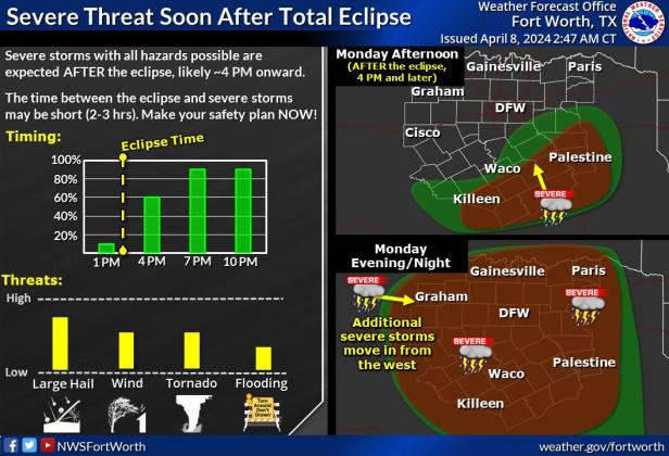 This National Weather Service graphic shows a multi-county area with a high possibility of storm activity this afternoon following the eclipse totality. COURTESY GRAPHIC | NATIONAL WEATHER SERVICE
National Weather Service meteorologists are predicting severe storms this afternoon after the total solar eclipse.
The NWS issued a hazardous weather outlook at 4:26 a.m. Monday for North and Central Texas, including Lampasas, Hamilton, Coryell, Bell and several other surrounding counties.
The outlook states severe weather is anticipated this afternoon, mostly after 4 p.m. The solar eclipse partial obscuration will begin in Lampasas at 12:15 p.m., and the totality will occur at 1:35 p.m.
“Thunderstorm chances increase this afternoon and evening,” officials said. “Severe storms with all hazards possible are expected after 4 p.m. into the evening. The primary threat is large hail, but tornadoes, damaging winds and flooding are all possible.”
NWS officials stated there may only be a short window of two to three hours between the end of the eclipse totality and the onset of severe weather. Officials encourage those traveling to plan their exit and have multiple methods to receive weather warnings.
The risk of severe weather will continue through Tuesday night.
“All hazards are possible with this activity. Flooding due to heavy rainfall will also be a threat through the midweek, especially east of I-35,” meteorologists said.
In anticipation of these storms, Reveille Peak Ranch in Burnet County has cancelled the remainder of today’s festival due to “risks of high winds, tornadic activity, large hail and thunderstorms” later in the day.
According to a release shared by the Burnet County Sheriff’s Department, camp officials are allowing guests to stay to view the eclipse, provided they are packed and ready to leave immediately afterward.
NWS meteorologists have predicted storms to affect Burnet County after 3 p.m.
DAILY FORECAST
According to the NWS daily forecast, Lampasas County will face a 50% chance of showers and thunderstorms today after 4 p.m. Some of these storms could be severe. The high is forecast as 79 degrees Fahrenheit with a south-southeast wind of 10-15 mph, with gusts of up to 20 mph possible.
Overnight, showers and thunderstorms will return after 4 a.m. Chance of precipitation will rise to 60%, and rainfall totals are expected at less than a tenth of an inch, with greater amounts possible during thunderstorms.
Showers and thunderstorms are likely before 7 a.m. Tuesday and will remain possible between 7 a.m. and 1 p.m., decreasing in likelihood after that time. The chance of precipitation Tuesday is 90%. New rainfall amounts between three quarters and one inch are possible, officials said.
Those rain chances will drop to 40% on Wednesday. Northwest winds of 15 to 20 mph are predicted, with gusts as high as 30 mph. Wednesday’s high temperature is predicted to reach 69 degrees.