

Fire risk to continue this week
Update: Texas A&M Forest Service data shows the Lucy Creek fire is 75% contained as of Monday at 8:41 p.m. Another fire reported northwest of Lometa in the area of County Road 2535 and CR 2509 was listed at 78 acres and 75% contained as of 9:32 p.m.
The Lampasas Cattle Auction has offered space in the barn to house animals displaced by the fires. Contact Andy at 512-902-3540
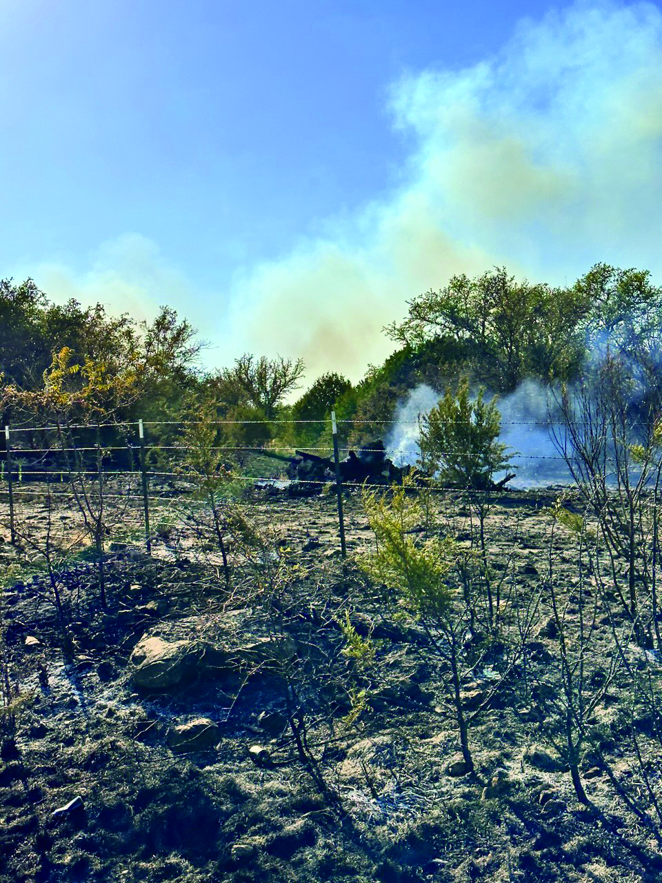
Triple-digit temperatures and gusty winds led to a 60-acre wildfire in Lampasas County over the weekend, and weather officials said the risks are ongoing.
The Lampasas County Sheriff’s Office responded to a report of a grass fire at 4:45 p.m. Sunday.
The Texas A&M Forest Service reported that a 60-acre blaze dubbed the “Lucy Creek fire” was about 60% contained as of 3 a.m. Monday.
That containment level held steady as of Monday morning at 9:45 a.m.
“We are at about 60% containment right now,” Lampasas Fire Department Deputy Chief Corey Greiner said.
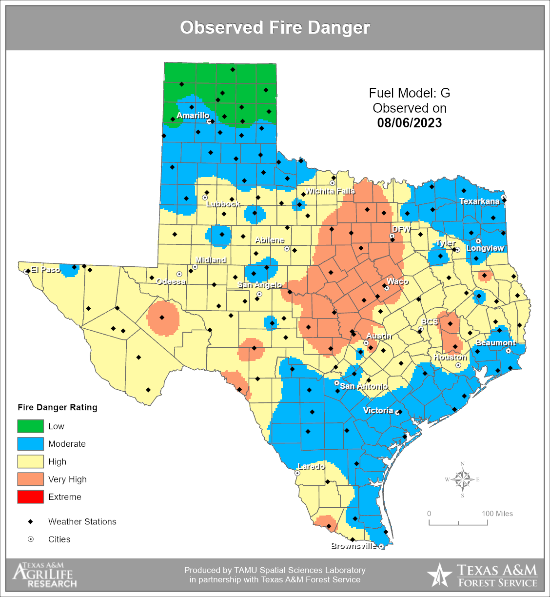
Conditions are dry, and winds are at 10-15 mph. High temperatures were expected to be 107 on Monday.
The Lucy Creek fire began in the area of County Roads 3420 and 3421.
A Dispatch Record reporter witnessed a large plume of smoke in the area about 5 p.m. Sunday afternoon and saw another smaller fire in the area of CR 3430 where it intersects with FM 580.
When asked if the fire on CR 3430 was related to the Lucy Creek fire, Greiner said, “I don’t know that right now. Just no way to really know that.”
LFD Deputy Chief Joe Adams believed the smaller fire on CR 3430 happened first and covered an estimated 2-5 acres.
“We were called to the 3430 fire first and had it controlled when we started diverting trucks to the 3420 fire,” Adams said.
In addition to Lampasas Fire Department, Lampasas VFD, Kempner VFD, Adamsville VFD, Lometa VFD and Texas A&M Forest Service responded to the Lucy Creek fire. The Texas Intrastate Fire Mutual Aid System also was deployed and was at the scene Monday.
The Mutual Aid System is maintained by the state forest service and is deployed for wildland fires anywhere in the state of Texas.
WEATHER CONDITIONS
An excessive heat warning took effect Monday, with temperatures in the triple digits predicted throughout the week.
The National Weather Service issued an excessive heat warning at 12:51 a.m. Monday, as well as a hazardous weather outlook for Lampasas, Coryell, Bell and other nearby counties, citing temperatures of up to 106 degrees and heat indices of up to 112.
“Dangerous heat continues across most of the region today with an excessive heat warning in effect along and south of Highway 380,” NWS officials said. “In addition, an elevated fire threat exists area-wide due to low humidity, exceptionally hot temperatures and very dry vegetation.”
The heat warning extended to 8 p.m. Monday evening, however high temperatures are predicted to remain above 100 degrees throughout the week.
In a hazardous weather outlook issued at 4:40 a.m. Monday, meteorologists said heat-related illness and critical fire weather conditions were the primary risks.
“Triple-digit temperatures and dangerously high heat index values will continue the potential for heat-related illnesses each afternoon across most areas,” officials said. “Elevated to critical fire weather conditions will continue daily as hot, dry and breezy conditions persist.”
As if that weren’t enough, North Central Texas may see lightning storms this week.
“Isolated storms are possible across parts of North Texas Tuesday,” NWS officials said. “Gusty winds will be possible with any stronger storms that develop.”
RED FLAG WARNING
This is the second heat-related notice issued in a matter of days.
At 1:01 p.m. Thursday, the National Weather Service issued a heat advisory for the 103-degree temperature and heat indices of 108 until 8 p.m. on Friday.
A red flag warning also was issued on Thursday afternoon and remained in effect until 1 a.m. Saturday due to gusty south winds.
“Rapid ignition and spread of wildfires is possible due to persistent hot and dry conditions,” NWS officials said. “A Red Flag Warning means that extreme fire weather conditions are either occurring now or will shortly. A combination of strong winds, low relative humidity and dry vegetation can contribute to extreme fire behavior.”
