

National Weather Service Meteorologists are predicting an ‘arctic front’ to arrive in Central Texas on Tuesday, bringing possible single-digit temperatures to Lampasas.
“An arctic cold front will arrive on Tuesday with temperatures falling during the daytime. Rain will accompany the front and may linger into the evening when temperatures fall below freezing,” NWS officials stated on the organization’s website. “This potential is highest across parts of North and East Texas where very light ice accumulations are possible, which could cause travel impacts to bridges and overpasses. Be sure to monitor the forecast heading into the workweek as these forecast details are refined.”
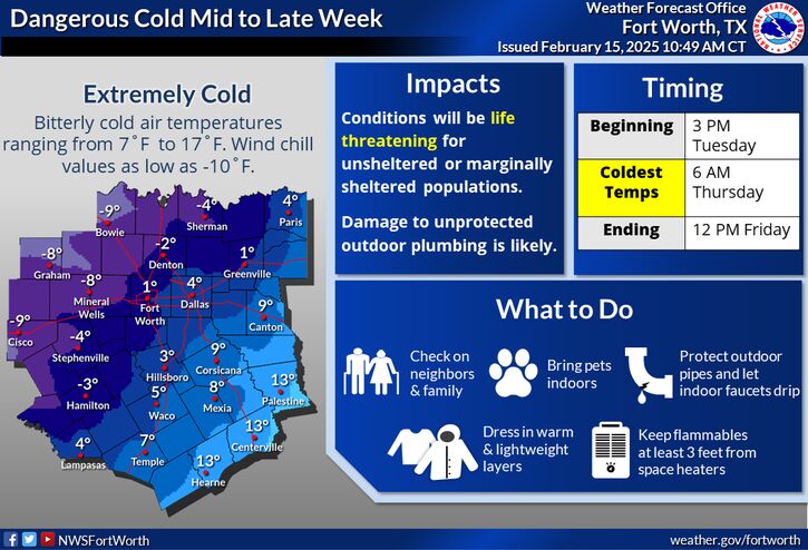
Temperatures of between 7 and 17 degrees Fahrenheit and wind values of -10 will begin at around 3 p.m. Tuesday and will peak at 6 a.m. on Thursday. NWS forecasts show that Lampasas may see a wind-chill adjusted low temperature of 4 degrees.
NWS officials described the temperatures as “life threatening to unsheltered or marginally sheltered populations,” and that damage is likely to unprotected outdoor plumbing.
Daily forecasts
Monday is forecast to be sunny, with a high near 61 degrees Fahrenheit. Winds will be 10 to 15 miles per hour with gust as high as 20 mph possible. Monday night will be mostly cloudy with a low of 49 and winds from 5 to 10 mph.
On Tuesday, Lampasas has a 20% chance of showers after noon and a high of 66 degrees. A south wind of 5 to 10 mph will pick up to 15 to 20 mph and shift north in the afternoon with gusts as high as 30 possible.
Tuesday night, temperatures will drop, with a low of 19 predicted. Chilly temperatures will last into Wednesday, which is forecast to have a high of 36 and winds of 15 to 20 mph with 25 mph gusts possible. Wednesday night will be mostly clear, with an anticipated low of 14 degrees.
On Thursday, the high is only predicted to reach 36, and temperatures may reach a low of 22 on Thursday night.
